3D scanning technology is another new surveying and mapping technology after GIS technology. Through fast and non-contact laser scanning of objects, high-precision 3D point cloud data of objects can be obtained and 3D virtual models of objects can be generated.
The measurement data obtained by using traditional measuring instruments such as total station and GPS, including the plane position and elevation of points, are in two-dimensional form, which can not fully meet the needs of intuitive 3D form description. The measurement information obtained by using a 3D laser scanner not only has the 3D coordinate information of points, but also can collect color and texture. While comprehensively restoring the surface information of building objects, At the same time, it overcomes the limitations of engineering survey.
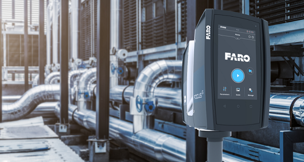
Faro Focus Large Scene 3D Laser Scanner
Faro’s latest ultra-portable focus large scene laser scanner can quickly, easily and accurately obtain the measurement results of complex objects and buildings. The focus scanner is equipped with a large, clearer and intuitive touch screen to provide users with an extraordinary experience. The built-in 8 megapixel HDR camera can not only capture detailed images but also overlay the scanned data captured under the condition of sharp brightness change. Many familiar features (such as small size, lightweight and 4.5 hours of rechargeable work at one time) make the focus laser scanner truly mobile for fast, safe and reliable 3D laser scanning.
Application Of 3D Scanning Technology In Engineering Survey
Deformation monitoring
In the past, most of the deformation monitoring of buildings used GPS or total station to continuously and regularly observe some deformation observation points, and evaluate the deformation through the comparative analysis of multiple observation data. This monitoring method can only measure the monitoring points in the discrete state, and there are omissions in mastering the overall deformation of the building.
Data acquisition with total station
By using Faro focus 3D laser scanner to quickly and comprehensively scan the monitoring object, a large number of feature point data of the monitoring object can be obtained quickly. After the intelligent point cloud processing of the software, the 3D model of the monitoring object can be quickly generated. Then, compare and analyze the scanning data regularly to generate a correct and complete deformation evaluation report of the monitoring object.
Road engineering and pipeline survey
Design and monitoring are areas often encountered in road engineering. Generally, single local measurement of points is carried out by using traditional measurement tools such as total station and GPS (RTK) to obtain discrete point data (similar to three coordinates in industrial measurement). The other is to take aerial photos and topographic maps as the data acquisition platform. The accuracy of the model information obtained by these data collection methods is difficult to guarantee, and it takes a long time, which is easy to be affected by the external environment. Faro focus is not affected by light and can be scanned in fog, rain, bright sunlight, or more extreme environments (such as desert).
Road ranging with level gauge
The point cloud data collected by Faro focus can avoid these errors to a great extent, so as to obtain accurate data of road conditions. However, the total station and traditional optical measuring instruments used in all kinds of traffic engineering, pipeline and line network laying have a high probability of measurement errors, and the abnormal conditions of the line can not be found in time. The use of Faro scanner to scan and measure the pipeline can not only ensure the accuracy of collected data, but also find the abnormal line in time.
Ancient architectural survey
Many ancient buildings use wooden structures, which are easy to be damaged. The accurate detection of ancient buildings and the discovery of potential problems are important work for the protection of ancient buildings. In the measurement and detection of the Forbidden City, traditional and 3D laser scanning methods are used for measurement and inspection. There are some problems in the size obtained by manual measurement or traditional instruments, and some necessary data cannot be measured, so the measurement error is increased. On the opposite side of the structure monitoring of ancient buildings, Faro focus has been widely used because of its measurement accuracy, speed, resolution, comprehensiveness and portability.
Decoration design
3D scanning technology is used to digitize the model of interior decoration. The scanned point cloud can be updated and designed, assembly comparison, pipeline design, etc. through Revit and other software. Use the model information to carry out digital simulation in the stages of design, assembly and construction, so as to reduce errors in the construction cycle and improve the accuracy.
Conclusion
Facing the surging tide of digitization and informatization, intelligent construction is bound to become the development direction of management transformation and upgrading of engineering construction industry in the future. Rongshunda will work with partners to provide whole process digital solutions in the construction of IT infrastructure, realize collaborative office, planning and supervision, so as to improve design quality, realize lean manufacturing, upgrade quality and safety management and other construction objectives.